


la chaussee st victor

gerardh
User
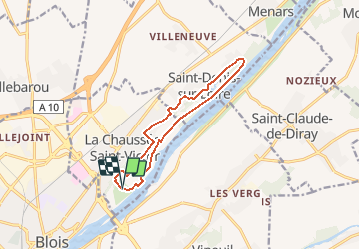

Length
10.9 km

Max alt
94 m

Uphill gradient
111 m
Km-Effort
12.4 km

Min alt
66 m

Downhill gradient
112 m
Boucle
Yes
Creation date :
2020-12-18 10:28:46.37
Updated on :
2020-12-18 10:29:54.612
2h44
Difficulty : Difficult

FREE GPS app for hiking
 SityTrail
IGN / Geographical institutes
SityTrail Plus
The world is yours!
About
Trail Walking of 10.9 km to be discovered at Centre-Loire Valley, Loir-et-Cher, La Chaussée-Saint-Victor. This trail is proposed by gerardh.
Description
depart parc des mees
st denis
bord de loire
Positioning
Country:
France
Region :
Centre-Loire Valley
Department/Province :
Loir-et-Cher
Municipality :
La Chaussée-Saint-Victor
Location:
Unknown
Start:(Dec)
Start:(UTM)
376573 ; 5273140 (31T) N.
Comments